You'll also like ...
Le séjour en bref
Infos pratiques
NIVEAU
i
Intensité Physique
i
Trustpilot
à partir de hors transport
du
au
le
Ce séjour n'est
pas disponible
pas disponible
Bouhhh
... It’s sold out!
... It’s sold out!
*Offre soumise à condition
réserverA BRIEF OVERVIEW OF THE TRIP
Nature escapeGuaranteed departure from 5 participants
Hiking (6 days)
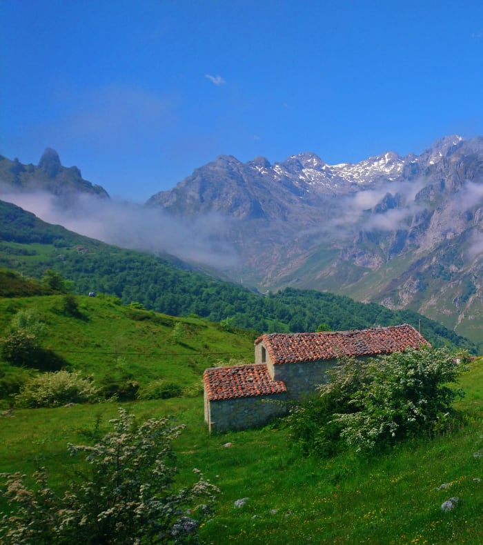
The province of Cantabria, in the east of the Spanish Basque Country, includes seaside landscapes, mountains with high jagged peaks and spectacular deep valleys. The Picos de Europa massif, or “Los Picos”, extends over 40 km long by 20 km wide, and culminates at the Torre de Cerredo at 2649m.
The National Park, located in the eponymous massif, was created in 1995, and is home to numerous endemic species, fauna and flora combined.
We invite you to discover this wild region, culminating in two hikes by the sea on a protected coastline that is just as spectacular.
Accommodations: Small hotels or bed and breakfasts.
Portage Light bag (4 to 5 kg).
A BRIEF OVERVIEW OF THE TRIP
Nature escape For sailors coming from the west, the Picos de Europa were the first lands visible on the horizon, which explains the origin of the name of this mountain range. Here is the opportunity to explore this wild territory on the sea and mountain sides!Guaranteed departure from 5 participants
Hiking (6 days)
The province of Cantabria, in the east of the Spanish Basque Country, includes seaside landscapes, mountains with high jagged peaks and spectacular deep valleys. The Picos de Europa massif, or “Los Picos”, extends over 40 km long by 20 km wide, and culminates at the Torre de Cerredo at 2649m. The National Park, located in the eponymous massif, was created in 1995, and is home to numerous endemic species, fauna and flora combined.
We invite you to discover this wild region, culminating in two hikes by the sea on a protected coastline that is just as spectacular.
Accommodations: Small hotels or bed and breakfasts.
Portage Light bag (4 to 5 kg).
THE BEST OF THE PRODUCT
- Discover a Spanish province far from the usual cliches
- Hikes by the sea and in the mountains
- Spectacular mineral landscapes
- A coastline between cliffs, waves, lighthouses and jagged strata
- The most beautiful “flysch” in the world
THE BEST OF THE PRODUCT
- Discover a Spanish province far from the usual cliches
- Hikes by the sea and in the mountains
- Spectacular mineral landscapes
- A coastline between cliffs, waves, lighthouses and jagged strata
- The most beautiful “flysch” in the world
OTHER ACTIVITIES INCLUDED IN THE OFFER
PHYSIQUE CONDITION
LEVEL OF PRATICE
LEVEL OF PORTAGE
Included
- Transfers/local transport
- Framing
- Accommodation (7 nights)
- The Fuente Dé cable car
- All breakfasts and dinners (except dinner on Day 7 and meals on Day 8)
- Lunch from Day 2 to Day 7 in the form of a picnic
- And in general all the services indicated in the program.
Not Included
- Drinks (even bottled water)
- Transport to the meeting point in Hendaye
- Lunch Day 1, meals Day 8
- Personal expenses and equipment
- Optional insurance as well as any other supplement not provided for in the program.
The program
Day by dayDay of arrival
Day 1: Hendaye/Picos de Europa National Park
Reception on Saturday at 2.30 pm at Hendaye train station. Transfer to the Picos de Europa National Park in northwestern Spain, a biosphere reserve straddling Asturias, the province of Leon and Cantabria.
Reception on Saturday at 2.30 pm at Hendaye train station. Transfer to the Picos de Europa National Park in northwestern Spain, a biosphere reserve straddling Asturias, the province of Leon and Cantabria.
4 hours of transfer, with a break along the way. Dinner and night in Sotres, a shepherds' village, at an altitude of 1000m.
During your stay
Day 2: Sotres/Tielve/Tour to Monte Camba
From Sotres we leave for a beautiful loop hike in Monte Camba. A stage that will take us through the village of Tielve.
From Sotres we leave for a beautiful loop hike in Monte Camba. A stage that will take us through the village of Tielve.
Sotres and Tielve, two villages linked by the breeding and production of the famous cheese, “Cabrales”, according to an ancestral method of production. Magnificent view of one of the peaks of the National Park, the peak “Naranjo de Bulnes”, with its 600m high vertical walls. Return to our accommodation, dinner and overnight stay on site.
14km, 4h30 of walking/Height difference +500m/-500m
Day 3: Naranjo de Bulnes
Short transfer to the Pandebano pass at 1250m (10 min). Pico Urriellu (or Naranjo de Bulnes) has an altitude of 2519m; it is not the highest peak in the Cantabrian Mountains, but it is one of the best known. Hike back and forth, we take our minivan back to our accommodation in Sotres. Dinner and overnight on site.
13km, 5h30 of walking/Height difference +950m/-950m.
Day 4: Poncebos/Ruta del Cares/Potes
Departure to Poncebos (20 minutes). A loop hike along the mythical “Ruta del Cares”, also called “La Garganta Divina”. One of the most spectacular routes in the Picos de Europa, in the middle of a mineral universe made of deep gorges, precipices and steep mountains... Back to our vehicle, transfer to the small village of Potes, a few kilometers from the Picos de Europa (1h15). Dinner and night on site in an inn.
22km, 5 hours of walking/Height difference +600 m/-600m.
Day 5: Fuente Dé/Horcados Rojos/Potes
Departure from Potes to Fuente Dé by vehicle. Ascend by cable car to an altitude of 2205m. Start of the hike to reach the Horcados Rojos pass in the heart of the massif, between Pico Tesoro and the Horcados Rojos Tower. It serves as a natural passage between the Cabana Veronica refuge and the Urriellu refuge. The ascent to the pass is already a superb excursion at 2343m. Reaching the summit at 2500m depends on the weather conditions and the motivation of the group. Descent by cable car where we meet our vehicle and return to Potes, dinner and night on site.
14km, 5 hours of walking/Height difference +450m/-450m.
Day 6: Coastal hike around Santoña
Transfer to the coast, in the region of Santoña east of Santander (2 hours drive)... Radical change of landscape, we are on the coast... a long loop hike alternating landscapes of oak groves and impressive cliffs... This route is of great interest from the point of view of the ecosystem of Cantabria, but also from a cultural point of view, but also from a cultural point of view with its lighthouses and forts, reflections of a centuries-old maritime tradition... This route is of great interest from the point of view of the ecosystem of Cantabria, but also from a cultural point of view, with its lighthouses and forts, reflections of a centuries-old maritime tradition... This route is of great interest from the point of view of the ecosystem of Cantabria, but also from a cultural point of view, with its lighthouses and forts, reflections of a centuries-old maritime tradition... hostel in Santoña.
12 km, 4h30 of walking/Height difference +600m/-600m.
Day 7: Deba - Zumaia coastal hike
Transfer to Zumaia in the center of the Basque coast (1h40). Hike corresponding to a stage of the GR 121 between Deba and Zumaia. The coastal coastline offers us here a landscape of spectacular beauty and of great geological interest... in fact, it is home to a 60-million-year-old treasure in the form of pleated “rock strata”, called “flysch”... this word of German origin comes from the verb “fliessen” (to flow), a terminology that is perfectly suited for these strata whose study tells us about events such as the extinction of dinosaurs. Free dinner and overnight in San Sebastian (35 minute transfer from Zumaia).
14 km, 4h30 of walking/Height difference +650m/-650m.
Last day
Day 8: Breakfast. Transfer to Hendaye train station, end of the program on Saturday at 11 am.
The course of this program is given for information purposes only.
The course of this program is given for information purposes only.
It may undergo modifications or adjustments, depending on technical criteria, safety requirements or the climatic conditions of the moment. In this case, only those responsible for UCPA supervision are authorized to take the necessary decision (s).
ABOUT THE TRIP
Equipment Included
No equipment provided by UCPA
Equipment Included
No equipment provided by UCPA
Equipment not included
Bring 2 pieces of luggage (attention, no more than 15 kg in total)
1 small backpack (35-40 liters) for the day.
1 sturdy travel bag or 1 large backpack to carry your personal belongings
1 small backpack (35-40 liters) for the day.
1 sturdy travel bag or 1 large backpack to carry your personal belongings
Recommended personal equipment
2 shorts
2 to 3 T-shirts
1 lightweight sweatshirt
1 swimsuit
1 cap or hat
1 windbreaker
1 or 2 lightweight cotton pants
1 swimsuit, sunglasses, sunscreen
Toiletries
Small personal pharmacy,
1 liter bottle, plastic bowl, pocket knife, cutlery (mixed salads)
Sandals and tennis for the evening
To walk
Trekking-type hiking boots, maintaining the ankle well with a good notched sole. Tennis totally not recommended because they are not adapted to the terrain.
Equipment not included
Bring 2 pieces of luggage (attention, no more than 15 kg in total)
1 small backpack (35-40 liters) for the day.
1 sturdy travel bag or 1 large backpack to carry your personal belongings
Recommended personal equipment
2 shorts
2 to 3 T-shirts
1 lightweight sweatshirt
1 swimsuit
1 cap or hat
1 windbreaker
1 or 2 lightweight cotton pants
1 swimsuit, sunglasses, sunscreen
Toiletries
Small personal pharmacy,
1 liter bottle, plastic bowl, pocket knife, cutlery (mixed salads)
Sandals and tennis for the evening
To walk
Trekking-type hiking boots, maintaining the ankle well with a good notched sole. Tennis totally not recommended because they are not adapted to the terrain.
formalities administratives
Indicative data for French nationals: valid national identity card or passport mandatory.
https://www.diplomatie.gouv.fr/fr/conseils-aux-voyageurs/conseils-par-pays/
https://www.diplomatie.gouv.fr/fr/conseils-aux-voyageurs/conseils-par-pays/
formalities administratives
Indicative data for French nationals: valid national identity card or passport mandatory.
https://www.diplomatie.gouv.fr/fr/conseils-aux-voyageurs/conseils-par-pays/
https://www.diplomatie.gouv.fr/fr/conseils-aux-voyageurs/conseils-par-pays/
Address and access
Program without transport, go to Hendaye station on J1 at 2.30 pm.
Address and access
Program without transport, go to Hendaye station on J1 at 2.30 pm.
Physical intensity
Regular sportsman
You practice a regular sports activity throughout the year, with 1 or 2 sessions per week. You are able to combine several moderate-intensity sessions during your vacation week.
You practice a regular sports activity throughout the year, with 1 or 2 sessions per week. You are able to combine several moderate-intensity sessions during your vacation week.
Level of expertise
Hiking - Level 2
For people who have already gone on a hiking trip and/or practicing endurance physical activity regularly.
For people who have already gone on a hiking trip and/or practicing endurance physical activity regularly.
Start of hikes with a drop in altitude, half-day or “short” day walking time. It is the beginning of the discovery of mountain paths.
Level of expertise
Hiking - Level 2
For people who have already gone on a hiking trip and/or practicing endurance physical activity regularly. Start of hikes with a drop in altitude, half-day or “short” day walking time. It is the beginning of the discovery of mountain paths.
For people who have already gone on a hiking trip and/or practicing endurance physical activity regularly. Start of hikes with a drop in altitude, half-day or “short” day walking time. It is the beginning of the discovery of mountain paths.
Portage
Carrying level 1
Bring personal belongings and picnics for 1 or 2 days.
3 to 7 kg.
Bring personal belongings and picnics for 1 or 2 days.
3 to 7 kg.
Portage
Carrying level 1
Bring personal belongings and picnics for 1 or 2 days.
3 to 7 kg.
Bring personal belongings and picnics for 1 or 2 days.
3 to 7 kg.
Restauration
Midday meals are picnics.
Breakfasts where we are staying. Hot meals in the evening, taken in various local restaurants (water, drinks not included).
Breakfasts where we are staying. Hot meals in the evening, taken in various local restaurants (water, drinks not included).
Restauration
Midday meals are picnics.
Breakfasts where we are staying. Hot meals in the evening, taken in various local restaurants (water, drinks not included).
Breakfasts where we are staying. Hot meals in the evening, taken in various local restaurants (water, drinks not included).
Management
Local French-speaking guide whose role is to guide you with maximum safety and to help you discover the environment.
Management
Local French-speaking guide whose role is to guide you with maximum safety and to help you discover the environment.
Important information
Physical intensity: **
This program is for anyone in good health and physical shape who is able to walk 4 to 6 hours a day.
This program is for anyone in good health and physical shape who is able to walk 4 to 6 hours a day.
These are day hikes, with short vehicle transfers to the starting point of the hikes. Carrying is therefore always reduced to a minimum, with a bag of 4 to 5 kg (carrying the day's things and lunch).
The terrain is very varied: good paths, steeper trails, but most often easy, with generally moderate differences in altitude (maximum of + 950 meters on D3).
220 Volt electricity, same sockets as in France.
The terrain is very varied: good paths, steeper trails, but most often easy, with generally moderate differences in altitude (maximum of + 950 meters on D3).
220 Volt electricity, same sockets as in France.
Important information
Physical intensity: **
This program is for anyone in good health and physical shape who is able to walk 4 to 6 hours a day.
These are day hikes, with short vehicle transfers to the starting point of the hikes. Carrying is therefore always reduced to a minimum, with a bag of 4 to 5 kg (carrying the day's things and lunch).
The terrain is very varied: good paths, steeper trails, but most often easy, with generally moderate differences in altitude (maximum of + 950 meters on D3).
220 Volt electricity, same sockets as in France.
Weather
Weather for the “Pico del Teide” program:
The climate is hot and dry for most of the year, although temperatures rarely exceed 30°C in summer.
The climate is hot and dry for most of the year, although temperatures rarely exceed 30°C in summer.
The rains are rare (31 rainy days in the year) and they fall mainly during the months of December, January and February.
The wind is quite strong throughout the year.
The sea temperature varies between 18°C in winter and 23°C in summer.
The summit of the island peaks at 3718 m, the altitude really changes the temperatures:
In Vilaflor (1400 meters above sea level) where you will be staying, it will be between 8°C and 9°C lower than the temperatures indicated above.
At sunrise at the summit of Teide, count about 22°C less than at the seaside.
Even in May or September the temperature can therefore be below 0°C.
Weather for the program “The Timanfaya Lavas”:
The climate is hot and dry for most of the year, although temperatures rarely exceed 30°C in summer.
Rainfall is extremely rare (20 rainy days over a year, mainly in December-January and February). The wind is quite strong throughout the year.
The sea temperature varies between 18°C in winter and 23°C in summer.
Weather
Weather for the “Pico del Teide” program:
The climate is hot and dry for most of the year, although temperatures rarely exceed 30°C in summer.
The rains are rare (31 rainy days in the year) and they fall mainly during the months of December, January and February.
The wind is quite strong throughout the year.
The sea temperature varies between 18°C in winter and 23°C in summer.
The summit of the island peaks at 3718 m, the altitude really changes the temperatures:
In Vilaflor (1400 meters above sea level) where you will be staying, it will be between 8°C and 9°C lower than the temperatures indicated above.
At sunrise at the summit of Teide, count about 22°C less than at the seaside.
Even in May or September the temperature can therefore be below 0°C.
Weather for the program “The Timanfaya Lavas”:
The climate is hot and dry for most of the year, although temperatures rarely exceed 30°C in summer.
Rainfall is extremely rare (20 rainy days over a year, mainly in December-January and February). The wind is quite strong throughout the year.
The sea temperature varies between 18°C in winter and 23°C in summer.
The climate is hot and dry for most of the year, although temperatures rarely exceed 30°C in summer.
The rains are rare (31 rainy days in the year) and they fall mainly during the months of December, January and February.
The wind is quite strong throughout the year.
The sea temperature varies between 18°C in winter and 23°C in summer.
The summit of the island peaks at 3718 m, the altitude really changes the temperatures:
In Vilaflor (1400 meters above sea level) where you will be staying, it will be between 8°C and 9°C lower than the temperatures indicated above.
At sunrise at the summit of Teide, count about 22°C less than at the seaside.
Even in May or September the temperature can therefore be below 0°C.
Weather for the program “The Timanfaya Lavas”:
The climate is hot and dry for most of the year, although temperatures rarely exceed 30°C in summer.
Rainfall is extremely rare (20 rainy days over a year, mainly in December-January and February). The wind is quite strong throughout the year.
The sea temperature varies between 18°C in winter and 23°C in summer.
Hosting
The first 3 nights in a hostel in Sotres, 2 nights in a hostel in Potes, 1 night in a hostel in Santoña, and 1 night in a hotel in San Sebastian.
Hosting
The first 3 nights in a hostel in Sotres, 2 nights in a hostel in Potes, 1 night in a hostel in Santoña, and 1 night in a hotel in San Sebastian.